
Professional aerial inspections and condition reporting for land, assets, and infrastructure, including after-hours
VertiView provides professional aerial inspections and visual condition checks for farms, properties, and infrastructure, delivering clear, practical insight from above.
About Us
VertiView is a locally operated aerial inspection service providing clear, practical insight for land and infrastructure.
Using commercially registered drones, we carry out visual inspections and condition reporting for farms, rural properties, and small industrial sites, helping clients identify issues early and make informed decisions without unnecessary time on the ground.
Operating within CASA regulations, VertiView focuses on safe, reliable, and repeatable inspections—delivering high-quality imagery, clear reporting, and a professional service tailored to regional and agricultural environments.
Our team of operators includes photographers, farmers, and private security professionals.
Services provided
VertiView has a list of standard services, however contact us for anything not already here - we are about finding solutions

Aerial Property & Asset Inspections
Visual inspections of land, buildings, and infrastructure to identify visible issues such as damage, wear, access problems, or changes in condition—without climbing, walking long distances, or disrupting operations.

Storm & Weather Damage Checks
Rapid post-storm aerial checks to identify roof damage, fallen trees, blocked drains, washouts, fence damage, and access issues, with clear imagery to support maintenance or insurance decisions.

Dam, Trough & Surface Water Checks
Visual assessment of dams, troughs, channels, and surface water areas to confirm water presence, access, and visible issues such as erosion, overflow, or obstructions.
Inspection Reporting
Clear, plain-English summaries with annotated images highlighting observations and areas of interest, delivered digitally for easy reference and record keeping.

Bushfire Readiness Check
Aerial visual inspections to help property owners assess bushfire preparedness around buildings and key assets. This service focuses on identifying visible risk factors such as vegetation buildup in gutters, clearance between bushland and structures, roof condition, and access to nearby water sources or fill points.

General Flight
Services not listed above can be booked as "General Flight" - This can be any other activity you require at a fixed hourly rate (within CASA approved operations)
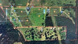
Some recent work
Looking at things I'm not supposed to
Drone Photography

From our customers
I have earned the trust and satisfaction from hundreds of customers, all over the country, by providing reliable, high-quality service. Check out what they reckon!
Follow us on instagram @instagram
Loading content, please wait...
Frequently Asked Questions
Here are some of our Frequently Asked Questions
Yes - All of our Operators are RPA Operator Accredited (or higher) by CASA. Our flight systems (Drones) are commercially registered as CASA Aircraft with permissions in their respective categories
Yes - Our fleet contains remotely piloted aircraft (Drones) that can be flown in the rain and some adverse weather conditions
Yes - Thermal imaging can be arranged by appointment
VertiView respects everyone's right to privacy in their own space, in accordance with applicable legislation.
Australian law does not provide an absolute right to privacy in public spaces. Airspace is regulated by CASA, and VertiView operates lawfully while applying strict privacy practices, capturing only imagery relevant to the agreed service and avoiding unnecessary identification of people or private activities.
Talk with the Pilot (Remote Pilot) about your concern
Talk with the Ground Crew / Support Crew about your concern
Email us your concern with support evidence (complaints@vertiview.com.au)
Report Unsafe Drone Usage https://www.casa.gov.au/about-us/contact-us/report-unsafe-drone-use